Here is a slideshow from my Alaskan Backcountry Adventure:
Glaciers
Alaska: As remote as it gets…
When I think of Alaska I think of mountains, glaciers, vast open spaces and unspoiled wilderness. About 6 months ago a friend of mine was gearing up for a very isolated trip into the Alaskan backcountry and through previous conversations, he knew that I would be interested. He had completed this trip twice in the past and now extended the invitation to me. No tourist boats, crowds or traffic to contend with, just float planes, fish and bears, exactly how Alaska was meant to be experienced. I have wanted to visit Alaska for quite some time now and I was ecstatic to get the invite. A river trip in the Alaskan wilderness 400 miles in the middle of nowhere, on a river that only sees a handful of people a year, fishing for salmon and trout in grizzly territory; count me in and let the planning begin.

Alaska state flag

The day had finally arrived and Kristy dropped me off at Denver International Airport. We had some nasty weather that day in Denver with tornadoes east of I-25 near the airport, so this added to the excitement. I made my way through security and met all the guys going on the trip at the gate. I am sure we looked like a bunch of excited school boys at recess with our fly rods attached to our packs and big grins on our faces hanging around the Anchorage gate. One of the ticket agents walked by with one of those “here’s your sign” questions and asked if we were going to be fishing in Alaska, we just smiled and said “yep.” If she only knew what we had planned. Our flight took off at 8pm and we arrived in Anchorage at 1am. The land of the midnight sun was living up to it’s reputation. As we neared Anchorage, you could see light on the horizon where the sun had gone down. This enabled us just enough light to make out the glaciers below on the St. Elias and Chugach mountain ranges, some of the most uninhabitable areas in Alaska. The St. Elias Mountains are the highest coastal mountains in the world and the Chugach range receives the most snowfall in Alaska, which results in the largest concentration of glacial ice in the state. We finally landed in Anchorage after about 5 hours of flight time. It was a cool 50 degrees with misty rain, typical for this time of year and our ride was there to greet us. We were going to stay at a friend of a friend’s house until the next days bush plane ride, when the real trip was to begin. When we arrived at his house near Chugiak, just north of Anchorage, 4 of us slept in his RV and the other 8 slept in his basement. Looking forward to the trip the following day, it was hard to get to sleep, but we only had a few hours of shut eye and I knew we were going to need it.

Our room for the evening
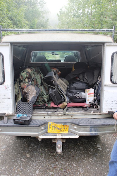
Loading the truck
We woke up the next morning and unpacked what we were going to need for the trip, then we loaded everything in the truck and grabbed some breakfast at the Eagle River Ale House. After breakfast we headed to Costco for food supplies and then to the newly opened Cabela’s for a few miscellaneous items. While outside you could hear and see the float planes flying around and the anticipation was killing me. I asked one of the guys who had been on the trip before what kind of planes we were flying and he said Beavers. I was a little apprehensive, as all I saw to this point were various configurations of bushwheeled and float Cessna’s which I have flown in many times before. I have had an obsession with the DeHavilland DHC-2 Beaver for a long time now and I was hoping I would have the opportunity to fly one in Alaska, after all it is THE Alaskan bush-plane. I was in team one, which was the first group to fly out. We were going to scout out the lake and river for the drop off of our gear and the other two groups which would arrive the following day. When we arrived at the float-plane base, which was a dock at Lake Hood right by Ted Stevens International Airport, there was no plane. I jumped out of the truck before we began unloading and searched for anything DeHavilland related to validate what we were flying, to no avail. We unloaded the truck and put all of our gear on the dock. The pilot had already staged all the camping supplies, rafts and bear boxes, so we field stripped and discarded unnecessary food packaging and loaded our food and cooking utensils into the bear boxes. This minimizes trash that would either have to be burned or packed out with us. While we were packing, I heard a prop turning in the distance. When I turned around a silver Beaver on floats rounded the corner and came to rest at the dock. I tried to stay focused on the task at hand, but I was easily distracted with it tied up next to us within arms reach. These aircraft are legendary and are the true workhorses of the Alaskan bush.
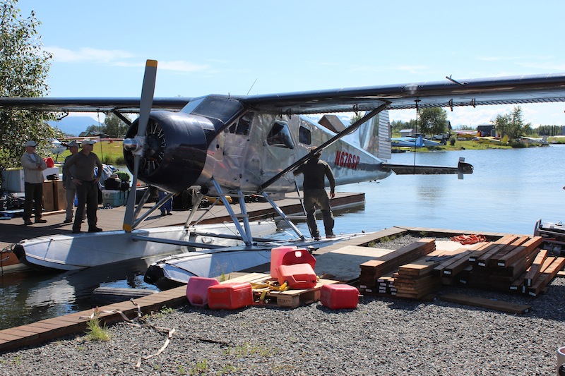
De Havilland DHC-2 Beaver
We met the pilot and began setting things aside that were a “must go” on the first trip. Once we had everything piled up, we weighed each piece and then added the passengers weight so the pilot could do the fuel calculations. I have talked to a lot of people who have been to AK and taken cruises, or short fishing trips on boats, or float planes, but this was a different kind of trip. We were getting ready to embark on a National Geographic style adventure 400 miles into the backcountry. You don’t want to be a liability to the group, so you better have all the required items. Once the plane left Anchorage, we were fully committed, there was no turning back and we were going to be at the mercy of wild Alaska and its notorious weather. We were going to be off the grid for 10 days with no cell service. We only had a satellite phone which was to be used in case an emergency extraction was necessary. This would be dependent on the weather at the time and where an aircraft could get in. Pretty exciting stuff!

Most of our gear on the dock
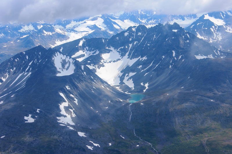
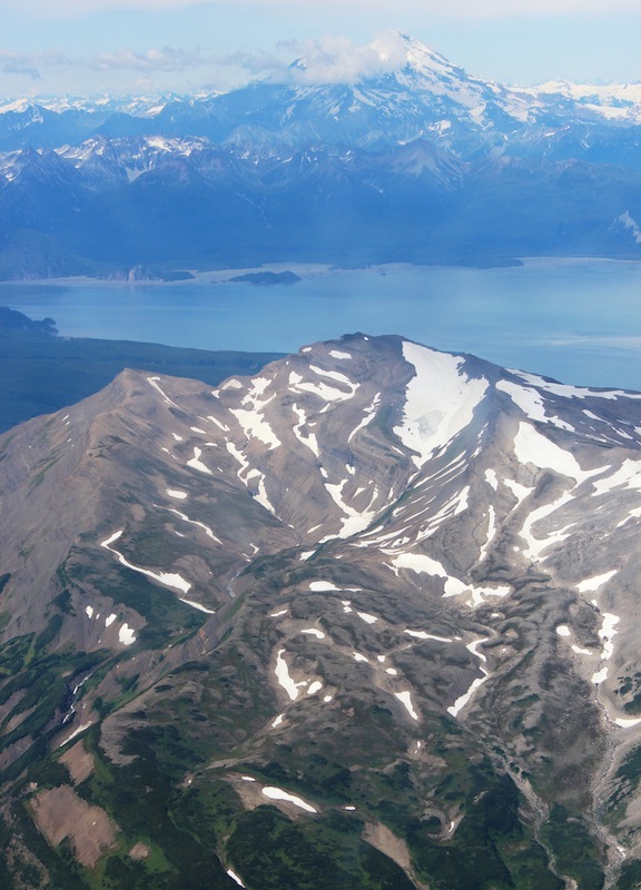
When we took off from Anchorage, we flew over the International Airport then over Cook Inlet and out towards Katmai National Park. Not until you fly at 5,000 feet in a bush plane, do you get the true sense of just how big and diverse Alaska’s landscape is. It is the perfect combination of Switzerland, Colorado and Hawaii with its (cold) ocean, (huge) lakes, (rugged) mountains, (icy) glaciers and (smoking) volcanoes. Skirting the tops of the mountains, looking down on enormous glaciers that turned into waterfalls, then into rivers that ran into the ocean was unbelievable. I was in awe at the unspoiled landscape. As we passed near St Augustine volcano, it provided us a fresh plume of smoke, just to let us know it was active. Alaska has a lot of volcanoes from the interior parts of the state all the way through the Aleutian Islands and we flew over quite a few. I tried to document the flight with pictures, but of course they do not compare to what we actually saw.

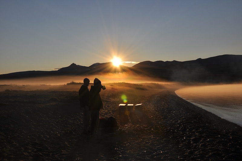
About 4 hours into the flight, the pilot pulled the throttle back, dropped the flaps and as the engine reduced speed we descended to an undisclosed lake, our own piece of paradise for the evening. We coasted down to the water with a smooth landing and he guided the plane to shore just west of where the river exited the lake. Bush pilots only get paid when the engine is running, so we quickly unloaded our gear and he was off again. We watched as he skimmed over the vast lake with a backdrop of snow filled tundra and rugged mountains. The pontoons lifted off the water and he circled around and tipped his wing, almost saying “good luck.” Not until then, did it set in. We were truly in the middle of nowhere.

The beach we camped at with the river to the left
It was about 7pm and the sun was still high on the horizon. We put our waders on, grabbed our firearms and went to scout out the neighborhood. There were bear trails all over the tundra and trampled growth up and down the river bank. The wildflowers were in full bloom and very similar to what we have in Colorado and the lake water was deceivingly deep and clear. There were no bears in the vicinity, so we made our way back to set up camp and make some dinner. The sun doesn’t set until about 11:00pm this time of year, so we had plenty of light left. We set our tent up facing the water with an awesome view of the lake and mountains. We heated some water and ate a Mountain House meal as a quick and easy dinner. After we ate, we began organizing our gear and we repacked the bear boxes and placed them away from camp. Just before the sun went down we spotted our first grizzly at the mouth of the river. His enormous light brown frame seemed to glow as the sun set. He was about 300 yards away and walked down river fishing with no issues. We were sure we would see him again.

11:00pm sunset
Around 6:00am sunrise
The next morning I was the first to get up, so I got the fire started and put the coffee on. It was a cool 38 degrees and clear with an awesome looking fog coming off the river spilling onto the lake. I took my baby-wipe shower and changed clothes and put the waders on in anticipation of some fishing. The guys slowly got around and we made some oatmeal for breakfast. We were in no hurry to do anything except fish, as the other planes were not due to arrive until about 2pm. The sun peeked over the mountains as we got our gear together. A school of bright red salmon swam in what looked like 2 feet of water off the shore. After wading in later, they were swimming in much deeper water than it looked it was so clear. We fished for a couple hours and hiked around the lake. Then we came back to camp and broke the tent and stove down and packed everything up just in time to hear the faint drone of a Beaver in the distance. It was the second wave of our party coming in to land. We unloaded their plane which had the heavy rafts, frames and oars in it, gained 4 more of our party and began building the rafts while we waited for the last flight to arrive. We had 4 rafts that took about an hour each to assemble the frames and air up. By the time we were finished, the last 4 guys arrived and we started packing the rafts with our gear and strapping everything down. We had a quick safety brief from the guys who had floated this river before and then we walked our boats to the mouth of the river. We were off!!

Safety Brief

1st section of river
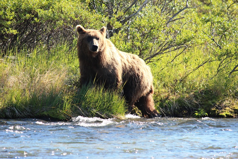
We had a total of 50 miles to cover over the course of 10 days and we wanted to get as much fishing in as we could along the way. Of course, there are no river reports in the backcountry, so you don’t know what you are going to come across. We brought saws along for the anticipated log jams we would encounter, bear spray, bear horns and shotguns for the bears and common sense for the unknown. The guys that had floated this river 5 years ago said they came across a log jam so bad, they had to empty all the boats, turn them sideways and walk them through an inch of water and then load them back up. This took them half a day. You must incorporate this possibility into the plan, as the extraction point is at a certain time and place and that plane is not going to sit around and wait. When the river was smooth we had to cover some terrain to make up for the time where we might face some obstacles. We floated about 9 miles that first day and saw 24 bears. At first it was a little unnerving floating close to an animal that powerful and aggressive, but you get used to it. You just have to be aware, keep your head on a swivel and you must spot them before they find you. You do not want to walk up on one, especially a sow with cubs. The closest we got to the bears was about 15 yards and that is close enough, as they have been clocked running up to 30mph. Luckily, they are fixated on the salmon in the river because they are fattening up for the coming winter. They are so distracted by the fish, sometimes we would surprise them as we floated by and they would back off and run up the shore, but sometimes they would see you and just stare as you floated by. They are well aware that they are the top of the food chain. On that upper portion we came around a bend in the river and there was a bear in the middle on a gravel bar eating a salmon and then we saw another on the bank fishing. We didn’t have anywhere to go, so we had to float between them. We were about 40 yards between two large bears and that provided for a nice pucker factor.
Friendly neighbor
Scott showing us how it’s done

Early morning bear watch
All of our camping spots were marked on the GPS by the guys on the previous trip, so we tried to stick to those. Sometimes we would get to that point and it wasn’t as good of a spot as they had remembered, so we would continue floating until we found a more suitable one. Some of the old sites were washed out, or the forage had grown up too much. When we found a spot everyone went to work pulling boats onto shore, unloading, setting up tents, setting up the kitchen, gathering firewood and getting the fires started. We always had two fires on either side of camp with the four tents huddled between. This was for “bear watch.” Bear watch began at 11pm and went until 7am in two hour increments. Everyone pulled bear watch in teams of three with rotating schedules, one person per fire and one rover. This was to dissuade curious bears that might wonder into camp. After all, we were eating their main staple, fish. We actually had a couple bears get a little too close a few nights, so we had to blow the air-horn to scare them away. The air horns were very effective and we hoped we wouldn’t have to resort to other means. At night, you could see their yellow eyes in the darkness across the river fishing, or you could hear them splashing in the water, but you couldn’t see them. It was one thing to spot them during the day and it was everyone’s responsibility to yell “bear!” if they saw one while walking around. It was a little eerie on the other hand seeing and hearing them at night via flashlight and headlamp, especially with those yellow eyes looking back at you through the dark brush when you were alone watching a fire.
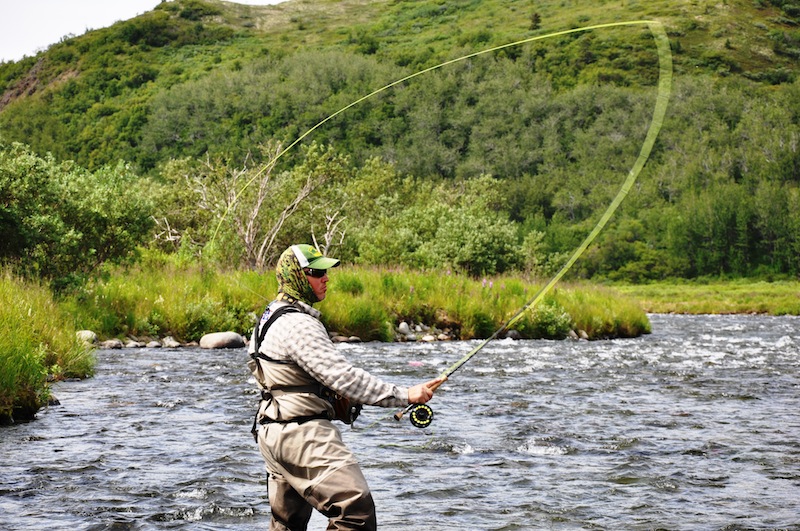
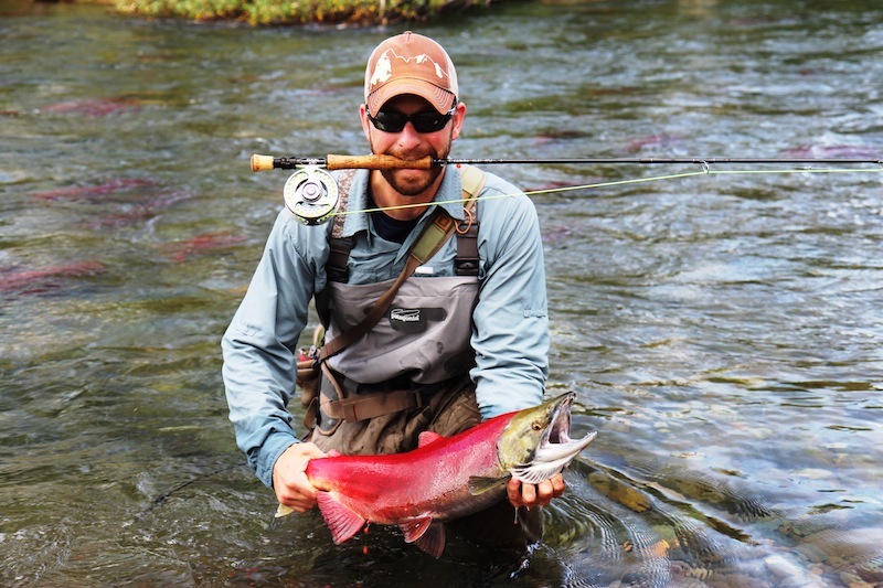
We continued down the river and stopped at the good fishing holes to take a break and drop a line. The salmon were all over the river and the rainbow trout and dolly varden swim underneath them during the spawning season eating their eggs as they lay them. Because of this, we mostly used egg patterns, but at times I threw a few streamers on as well. The egg patterns turned out to be the best for this time of year. I still remember seeing that indicator dip below the water when I caught the first salmon. I thought I had hung a rock and then the “zzzzzzzzzzzzzzzzzz” sound of the fly line spooling off the reel. I could see a faint red spot at the end of my line moving into deeper and faster water. About 5 minutes later, I fought him close enough to net and it was about an 8-10 pound salmon. We caught lots of salmon and rainbows, but mostly dolly varden (Arctic Char), which are in the trout family and really good to eat. One evening we had a stringer that must have weighed 30 pounds full of dolly’s and bows. We were frying fish late into the evening that night. The river was so loaded with fish it was ridiculous. I have to use a quote from Jimmy Mayhugh Sr “Alaska is the only place in the world you can cast a line in a puddle of water in the middle of the highway and catch fish, the wilderness is matched by none, Alaska is the grandfather of Colorado and I’m glad God saw fit to give us both.” Well said Jimmy. Sometimes you would accidentally catch one on your back cast… Lot’s of fun!

Luckily the water was running fairly high and we only had to jump out to pull the boats over the shallows a few days, which was exhausting because they were loaded and heavy. Further downstream we were ahead of schedule, so we were able to stay two consecutive nights at two different campsites. This enabled us to dry out some gear and get some really good fishing in as we could walk up, or down stream of camp. There were a couple of rules to that: you always go with someone, always bring a firearm and always yell “bear” when you see one, so everyone you are hiking with will know where it is. We were averaging about 12 bear sightings a day, so we were truly living with them. On one occasion I walked down river with a buddy who said he found a nice fishing spot that we had to try. It was about a 15 minute walk from camp through the woods. Once you go into the brush in AK, you disappear it is so thick. There are no hiking trails out here, so we walked the bear trails down the banks yelling “here bear” ever 5 seconds or so to warn a bear we could not see that we were coming. We felt like bear bait walking their trails stepping over half eaten salmon carcasses and dodging fresh steamy bear scat.
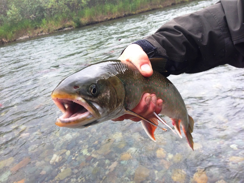
Dolly Varden
With only two cold rainy days, we lucked out and had some great weather on the trip. We had no issues going down river except when we lost an oar and I had to jump in to get it, soaking the inside of my waders with 54 degree water. This took a while to dry out… We also came across one log jam with two fallen trees on the last day. We had to get the saws out and cut a tree in half and pull it out of the water and then saw all the limbs off of the larger one. The large one was too big to cut in half and there was barely enough room to walk the boats underneath the trunk. This was the last leg of the river and we were trying to get to the extraction point by a certain time. We had to take turns rowing against the wind that we were heading into. It was blowing just enough to get you sideways if you weren’t consistent. After a week on the river with little sleep because of bear watch and true darkness only 4 hours a night, we were exhausted. We finally made it to the landing zone about 1pm, unloaded and pulled the boats out of the water and broke them down. A little late because of weather, the first plane landed on the wide-open portion of the river and we were able to load all the heavy camping gear and boats in it. Then we waited for the other two planes to pick us up. It was an uneasy feeling with the cloud deck lowering and cool, misty rain falling, thinking about all of our gear that had just flown out. What if something happened? What if the weather deteriorated to where they couldn’t fly in to get us? We had our weapons, bear spray, a tarp, backpacks and one jar of peanut butter, which was our lunch. We passed it around using a small birch limb as a spoon while we talked about what we would chow down on when we made it back to civilization.

Pulling the raft back up river to a better camp site
Laying back on our packs in the marsh with Mr Sandman knocking, we heard the plane fly over. Slightly rejuvenated from our protein packed lunch and bit of relaxation, we loaded it up and I quickly jumped in the co-pilot seat so I could get some good pictures on the way home. We were taking a different route back to Anchorage through a mountain pass and I wanted to see it all. We flew up the river a little ways where we had just floated and then over some enormous blue and emerald lakes. We stopped at a village to refuel the plane on one of the smaller lakes and we spotted a tiny cabin that the pilot said was a “convenience store.” One of the guys bought everyone Snicker’s bars for $2 each and it was probably the best candy bar I have ever eaten. Back in the air, the terrain began getting more rugged and mountainous and glaciers started appearing everywhere. I didn’t know which side of the plane to take pictures on, our surroundings were unbelievable. Once through the pass we descended and flew over some low marshy terrain with lakes and rivers. I spotted a few moose near one of the lakes below and some beluga whales swimming in an ocean channel. Just ahead I could see Anchorage on the horizon. After a diet of oatmeal, rice, granola and fish, I was ready to eat some real food. I wanted a steak. When we got back to our hosts house, we all showered and they grilled porterhouse for everyone with baked potato, salad and of course some Alaskan beer. What an ending to an awesome week in the backcountry.

Pretty sure I was cursing the wind at my back

Amazing trip!!
Sadly, our flight home was the following day at 1am, so we only had one day in Anchorage. Some of the guys wanted to do some laundry and relax and of course that was a waste of time to me, I was gunning to see some of town and hopefully check out some local brew. After all, I was still on vacation and can relax at home!! They dropped a few of us off downtown and we explored a bit and ended up at the Moose’s Tooth Pub. We ordered an amazing chicken pesto pizza and paired it with a few local beers to help wash it down. I especially enjoyed the Polar Pale Ale and the Bear Tooth Ale from Broken Tooth Brewing. We had a great time reminiscing about the trip, telling fish stories and of course talking about our closest neighbors, the 121 grizzly bears we saw. I recently came across a quote that fits this trip perfectly from an unknown source: “It cannot be explained, it can only be experienced.” After eating and hanging out for a while, we met up with the other guys and made our way to the airport. I think I am going to miss having to carry a weapon to use the bathroom while wearing a mosquito net and talking to the bears. In my opinion, Alaska is the perfect destination, accurately named “the last frontier” and I look forward to future conquests. Until next time Alaska…
**Most of the photos included in this post are the property of JKB Adventures, while some were taken by other members on this trip**
Video/slideshow:
Chugiak Mountain Eve – ONCE upon a winter’s eve, I found my person walking upon the snowy banks of some mountain carving river midway into the heart of Alaska’s Chugiak Mountain range. The air was crisp and sharp in winter’s thrall and the heavy-laden branches swayed and groaned under their silvery burdens. The sky overhead shone faintly as father Sun prepared to make his bed in a hanging glacial valley far behind the realm of human comprehension. Right now he was just brushing his celestial teeth.
Peaks and ridges backlit with the dusky rose haze of alpenglow cast the whole frozen world in a pink light that warranted an argument. For none was needed. Here was a place of peace. Untouched primal beauty as it was in the old days. I felt that by even being in this magical place that I was in some way interfering in the very balance of nature. For all of the serenity and peace that was granted to me by those mountain gods of their range, alas, I was an interloper yet. – Nicklaus Sorum
Cool travel Alaska video: HERE
Mt Rainier Summit Climb
“Getting to the top is optional. Getting down is mandatory.”
– Ed Viesturs
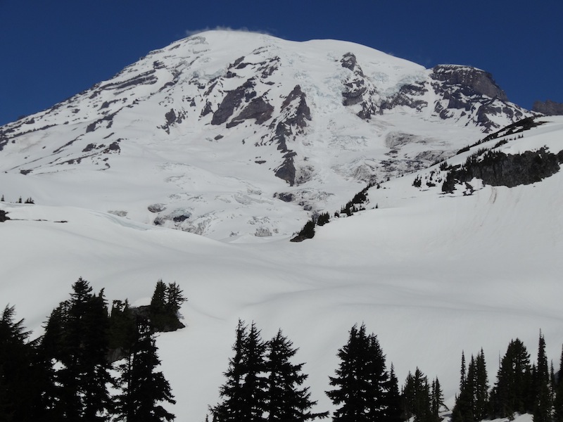
Mt Rainier
Ok, so the mountain bug bit me hard and I thought it was time to take it to the next level, so I planned a trip to climb Mt Rainier. From the time I committed to climb with Rainier Mountaineering Inc. (RMI) and made travel plans, it took about 6 months to get all of my gear ready. This would be one of my largest endeavors to date and I hoped my training was adequate and that the mountain would grant me passage. Our basement was completely cluttered with my climbing gear and the supplies I would need for the trip. I finally had things organized, laid out and K helped me with the checklist, twice. K was going to stay at Rainier base camp while I climbed and then we would spend a few days in Seattle after the summit attempt.
Mt Rainier is a massive stratovolcano located southeast of Seattle, WA. It is the most heavily glaciated peak and the most topographically prominent mountain in the continental United States outside of Alaska. The broad summit of Mt Rainier has three named peaks and the true summit is Columbia Crest at 14,411 feet.
We took a direct flight from Denver to Seattle and drove southeast to Ashford, Washington, which is where RMI is based. K went with me to the orientation class given by our RMI lead guide. He went over the history of mountaineering on Mt Rainier, what to expect and what their expectations were of our team of eight. After our brief orientation, we gathered our packs and boots, and the guides went through all of our gear and equipment to make sure it was functional and that we had everything we needed. We were then dismissed, as we had an extensive training class planned for the following day to make sure everyone knew what they were doing and how to deploy the proper equipment.
The team met up at Rainier base camp the next morning for training and we made our way up to Paradise at about 5,000 feet. This training was a good refresher, but it was nothing I had not already learned through the Colorado Mountain Club. We went over rescue techniques, rope travel and the proper deployment of ice tools. After a full day with clear blue skies, we were ready for the climb.
7:00 am came early the next day and K dropped me off at base camp. This time we said our goodbyes and she wished me luck as I carried my pack over to the group. Excitement was in the air as we boarded the bus, but there was a slight lack of optimism in the weather. The team that attempted to summit the day before was forced to turn around at 13,000 feet due to 80+ mph winds and whiteout conditions. There was a low pressure weather system that blew in and it was now raining at base camp. Unfortunately, there was another low pressure system following this one, so our optimism for making the summit was low. We had light snow and low visibility at the Paradise trail head as we gathered our gear. We stepped off about 9:30am and headed up the trail from 5,400 feet hoping the weather would improve.
We slowly made our way up the mountain in soft snow trying to follow the footprints ahead of us. We were still in a cloud, so there was no scenery. One step at a time, praying for the weather to break, we kept pushing on. About an hour or so into the climb, we took a short break. The temps were in the low 30’s, which was actually warm considering we were on the side of a mountain. We had 4,500 feet of elevation to gain the first day before we made it to Camp Muir, 10,080 feet above us. We continued on, taking breaks every 1,000 feet of elevation or so and readjusting our clothing for the cooler temps, re-hydrating and eating.
We could not see Camp Muir until we were literally on top of it, so there was no way to gauge our distance. We only had the footsteps in front of us, our breathing techniques and the rest step to concentrate on. We were all glad to finally arrive at Camp Muir around 4:30pm. We dropped our packs and began getting our sleeping bags ready for the brief “break” before gearing back up at 12am. As we were eating dinner, we noticed slight breaks in the clouds. This gave way to partial clearing which revealed 12,281 foot Mt Adams in the distance and the Cowlitz Glacier in front of us that we would later traverse. We were elated to see the sun and what looked like promising weather ahead, so we snapped a few photos and videos and then returned to the bunkhouse.
I don’t think anyone slept as every time someone would get into their sleeping bag, someone else would get up. It must have been the excitement in the air, or the over-hydration for the upcoming adventure… After a few sleepless hours, it was my turn… I got up to go to the bathroom and looked up to nothing but stars. The moon gave off just enough light that you could see the cloud deck far below us and a huge shadow of a mountain in front of us, Mt Rainier.
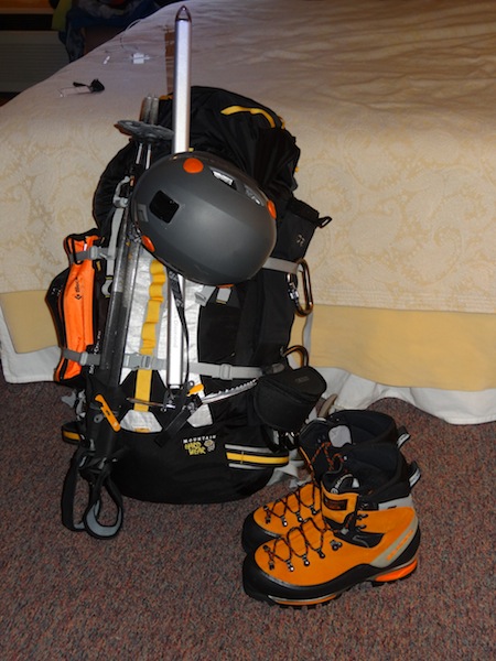
Packed and ready to go
At 12:00am, we woke up, got dressed and got our packs ready. I choked down a double dose of instant coffee and oatmeal. Not exactly the breakfast of champions, but we needed to start with some energy in the tank. We attached our crampons to our boots, put on our harnesses and helmets, grabbed our ice axes and roped up.
We were off at 1:00am and with the stars above and blackness surrounding us, the only light pollution was our headlamps. Looking ahead, we could only see the climber in front of us, our ropes and the trail. We slowly made our way across the Cowlitz Glacier and ascended Cathedral Gap. At one point we had to short rope and move quickly as there were large seracs above us that threatened to fall. We were very aware and listened for anything that sounded like it was coming at us. On a few sections we had one foot in front of the other as the ridge was so narrow. Pressing on up Cathedral Gap and onto the Ingraham Glacier, we finally took a much needed break. Immediately, we dug out our heavy parkas to keep from freezing and to hold onto the heat we had generated. After a brief 15 minutes and taking in some much needed calories and water, we were off again. We headed up the “flats” and up through Disappointment Cleaver. Periodically, you could see a huge crevasse off to one side or the other. These blue crevasses could be hundreds of feet deep. We stepped across a few and crossed one via a snow bridge. At one point, we traversed a crevasse with a board across it that was frozen in place. Don’t look down!! It was really getting steep and we would alternate using the crossover step as you could not keep your entire crampon in the ice walking straight up. I think around this point the sun began to peak over the horizon. The darkness in front of us gave way to a pale blueish gray that reflected from the ice and snow around us. We were far above the sea of clouds below, which provided a strange sensation. As the sun rose above the clouds, there was almost an immediate glow of orange on everything. Even the cold blue ice seemed to be warmed by the rays. We momentarily stopped to take pictures and you could see the smiles on everyone’s face. It seemed to take away a little of the pain, briefly…
We were at about 12,300 feet now and the mountain was not giving up. It was proving to be quite a monster. Our legs were jelly and quivering with each step. Unfortunately, at about this point three climbers ended their summit bid. One was showing signs of altitude sickness, one had swollen and blistered feet and one was exhausted. Remember, making it to the summit is only the halfway point and a one way trip was not an option at the ticket counter. It is round-trip, so you have to conserve enough energy to get down safely. Typically, most mountaineering accidents happen on the descent as this is when fatigue sets in. Some people have a surge of adrenaline near the summit that drains them for the trip down. This provides quite a challenge for the rest of the team to get them and their equipment down safely. Pacing yourself and proper nutrition and hydration during the ascent are the key to making the summit and still having the energy to get yourself down. We did not want to see them turn around, but know that they made the right decision.
After another hour, we took our final break, the “high break”. This was just above 13,000 feet. The low pressure system that was following the first one began showing itself. At first, light wispy cirrus clouds appeared overhead, which quickly turned into thick clouds and snowfall. From here on up, it snowed and the wind whipped our faces. Our visibility went south and the glaciers and snow mirrored the cloudy, snowy sky. The five of us with the guides pressed on through the crevassed glaciers of the upper slopes. Switchback after switchback we slowly crawled up the side of the mountain. Looking up every few minutes, you would think you would see the summit and then another obstacle would present itself. I could feel my feet swelling in my boots, no blisters, just a heavy swollen feeling. Finally, I saw some volcanic rocks through the snow above me. Could this be the Crater Rim?? I side stepped up and it leveled off. We had reached the Crater Rim at 14,000 feet. We probed for crevasses to find a resting point and waited for what was left of the team. We all congratulated each other, dropped our packs in exhaustion, put our parkas on and ate and drank like kings. Frozen Cliff Bars, trail mix and jerky is hardly eating like a king, but I had saved a Snickers bar for the summit. I left it in my pocket to keep it from freezing solid, so I ate it like I stole it. Even though it began to freeze as I was chewing, it was the best thing I had had all day. Our guide knew that two of us were willing and able, so we grabbed our ice axes and headed for the true summit, Columbia Crest. The other three climbers were to stay where they were and rest for the descent, but we continued to the other side of the crater and up the remaining vertical “few” feet, which took about an hour. Even though we had no view because the weather deteriorated, it was awesome to finally be atop Mt Rainier!! After a few quick pictures and high fives, we returned to the team, packed our gear and began the arduous descent.
Descending is sometimes even harder than the ascent, as foot placement is even more critical. Couple that with jelly legs, aching knees and sore feet and it sucks… We made pretty good time until we reached the cleaver, where two members were almost incoherent. They were in the middle of both rope teams, as we knew they were in bad shape. They were falling into the lead climber and tripping over their own crampons. We stopped so we could get them some water and much need sugar and carbohydrates. After 15 minutes, they were ready to keep charging down.
On our return traverse of the Cowlitz Glacier we were really feeling the microwave effect. We were still in a cloud and it was snowing, but because of the sun’s radiation being trapped between the glacier and the clouds, we were drenched in sweat and essentially cooking. Our faces and nostrils were burnt from the reflection of the glacier and a glimpse of Camp Muir was all we wanted. Finally it was in sight and the hardest part of the mountain was behind us, or was it? We rested for about an hour, filled up our water bottles, met up with the climbers who had left us earlier and continued down as a team. I thought this was going to be the easy part… More weather moved in on our way down, which brought driving sleet and near whiteout conditions. There was no trail to follow as we were descending a snowfield. Three hours later the good ole’ GPS brought us to the Paradise parking lot. What a welcome sight!!
We arrived at base camp all telling war stories from our time on Mt Rainier. Of course, as the beer flowed, the stories got better. 😉 After congratulations from our guides and other climbers, those of us who summited received the gold trophy, the RMI Mt Rainier summit certificate. Once back at our room, K said I dumped my pack and was completely out until morning.
What great training and an awesome experience. Mt Rainier, I will definitely be back.
Watch my Mt Rainier movie below:
